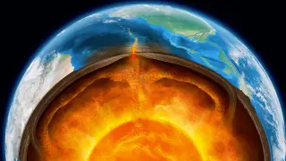
A rock sample from Papua New Guinea reveals that subduction zones may have complex thermal structures, with unexpectedly high temperatures at shallow depths followed by cooler conditions deeper down, challenging current geological models.
New research indicates that seismic activity in Italy's Apennine Mountains is primarily driven by the peeling away of the lower crust into the mantle, a process known as delamination, rather than traditional plate subduction. This 'unzipping' mechanism explains the region's complex mix of compression and extension, with implications for understanding similar tectonic transitions elsewhere.
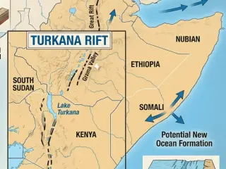
A new study in Nature Communications reveals that the Turkana Rift in East Africa has entered a 'necking' phase, where the crust has thinned to approximately 13 kilometers at its center. This indicates that the continental breakup of Africa into the Nubian and Somali plates is progressing faster than previously estimated, potentially leading to the formation of a new ocean in a few million years.
New seismic data reveals the Turkana Rift in East Africa has entered a 'necking' phase, indicating the continent will split sooner than previously estimated. This geological shift not only accelerates the formation of a future ocean but also explains the exceptional fossil preservation in the region, linking tectonic activity to the record of human evolution.
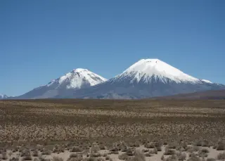
A massive volcanic eruption in northern Chile 22 million years ago buried an entire landscape, preserving a snapshot of the Andes' early formation. Researchers used the geometry of this deposit to calculate that the mountains were rising slowly, at a rate of less than 0.26 kilometers per million years, supporting the theory of gradual tectonic growth.
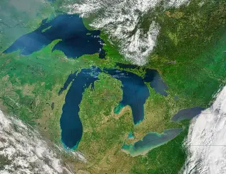
The Great Lakes are geologically young, having formed only about 10,000 years ago after the Ice Age, whereas some of the world's oldest lakes, such as Lake Baikal and Lake Tanganyika, have existed for millions of years. While the Great Lakes are recent postglacial features, ancient lakes in Africa, Asia, and Russia have persisted through vast geological timescales, often due to active tectonic rifting that maintains their basins. This stark contrast highlights that the Great Lakes are among the youngest major lake systems on Earth, with their entire modern history fitting into a tiny fraction of the lifespans of these older, enduring water bodies.
A new study led by Stefano Tavani of the University of Florence proposes that Earth's crust is undergoing a process of delamination beneath the Apennine Mountains in Italy. This 'unzipping' mechanism, where dense lower crustal layers peel away and sink into the mantle, explains how the region simultaneously experiences compression and extension. The findings, published in Communications Earth & Environment, suggest a migrating hinge front is responsible for the current geological paradox, replacing earlier theories that relied solely on slab rollback.
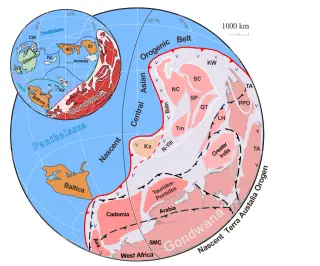
A study published in Science Advances confirms that the ancient landmass Gondwana was a true supercontinent, covering 80% of Earth’s landmass 500 million years ago. By analyzing over 25,000 rock samples, researchers identified hidden fragments of Gondwana buried under modern continents. This discovery links the supercontinent’s formation to the Cambrian explosion, as volcanic activity from its surrounding tectonic ring warmed the planet and enabled complex life to flourish.
UC Riverside researchers used GPS data and an algorithm to identify locked, stress-building portions of major faults (asperities) to indicate where the next large earthquake is likely to rupture. In tests, the model highlighted the Kamchatka subduction zone before the 2025 quake, suggesting potential for long-term hazard mapping, though it cannot predict timing or tsunami size; the team plans to apply the method to other subduction zones for improved preparedness.
New evidence shows the Great Unconformity wasn’t caused by a single global ice age; instead, massive erosion and crustal exhumation occurred during the assembly of ancient supercontinents, particularly Columbia between 2.1 and 1.6 billion years ago, with regional timing varying and suggesting multiple unconformities rather than a global wipeout, reshaping ideas about Earth’s history and the drivers of the Cambrian explosion.
Zealandia is a coherent continent-sized crust of about 4.9 million square kilometres, roughly 94–95% submerged in the South Pacific, making it Earth’s eighth continent by geological criteria. Its classification rests on four tests (elevation above the seafloor, distinctive geology, continental crustal structure, and a sufficiently large, well-defined area) and is supported by rocks, gravity, seismic, and magnetic data linking offshore ridges to onshore belts. Separation from Gondwana began around 105–85 million years ago as the Tasman Sea opened, with modern mapping (2023) tying the submerged edges together at reconnaissance scale. The size is about 1.5 times India’s land area and roughly two-thirds the size of Australia, and while school maps commonly show seven continents, Zealandia’s status reflects geological, not cartographic, convention. There is no global authority mandating a continent count, so Zealandia’s “eighth continent” label remains a scientific classification rather than a universally official designation.
New high-resolution 3D simulations indicate Venus's crust is still being stretched by interior heat, forming giant rift valleys and suggesting recent or ongoing tectonic activity; Magellan radar maps resemble young rift flanks, and upcoming missions VERITAS, DAVINCI, and EnVision will probe Venus’s active deformation.
Japan sits on the boundary of four tectonic plates along the Ring of Fire, triggering frequent, large earthquakes. The Kumamoto quake and other events highlight both the country’s advanced detection, emergency response, and quake-proof infrastructure built since major past disasters like Kobe and Tohoku, and the persistent seismic threat. Scientists warn of a future megathrust along the Nankai Trough with a 70–80% chance of an 8–9 magnitude quake within 30 years, though exact timing remains uncertain, underscoring the ongoing need for resilience and preparedness.
Mercury has cooled enough to shrink its radius by roughly 1–7 kilometers, leaving long lobate scarps that wrinkle the planet’s surface; recent analyses place the amount of contraction near 6.3 km when wrinkle ridges are counted and about 1.2 km when they’re excluded, highlighting a debate over whether the deformation records global shrinkage or mainly local faulting. The upcoming ESA–JAXA’s BepiColombo mission, arriving in 2026–27, is expected to help resolve how much of Mercury’s contraction is global versus localized.
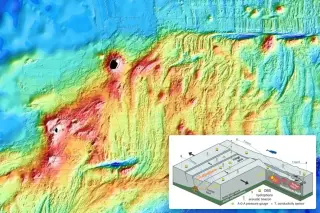
Scientists using an undersea observatory at the Southeast Indian Ridge captured a rare, real-time birth of new seafloor during a 2024 tectonic event, revealing seafloor spreading can occur in dramatic bursts rather than steadily and opening new avenues for marine geophysics.