Tag

Earth

All articles tagged with #earth

Earth’s Quiet End: A Brighter Sun Could Turn Our Planet Venus-like in About a Billion Years
science18 days ago

Earth’s Quiet End: A Brighter Sun Could Turn Our Planet Venus-like in About a Billion Years

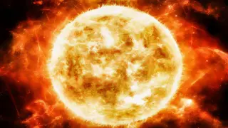
As the Sun brightens over roughly the next billion years, Earth’s climate will gradually lose atmospheric CO2, undermining C3 plants and triggering a moist greenhouse that erodes oceans by allowing hydrogen to escape to space. This slow process could render Earth uninhabitable long before the Sun becomes a red giant, gradually stripping away breathable air and water and pushing the planet toward a Venus-like state. The one‑billion-year timeline is uncertain and climate feedbacks like the carbonate-silicate thermostat can delay outcomes, but the overall arc points to a hostile, sterilized Earth long before the Sun’s ultimate evolution.
Earth’s oxygen era has a ticking clock: ends in about a billion years, study finds
science22 days ago

Earth’s oxygen era has a ticking clock: ends in about a billion years, study finds

A Nature Geoscience study using 400,000 computer-model simulations estimates that Earth’s oxygen-rich atmosphere will persist for about 1 billion more years, after which rapid deoxygenation could leave the planet with low oxygen, higher methane, and no ozone, potentially resembling pre-Great Oxidation Earth and affecting how we search for life on exoplanets.

Moon could form in just five hours after Earth-Theia collision, study suggests
space1 month ago

Moon could form in just five hours after Earth-Theia collision, study suggests

A new simulation-based study suggests the Moon could have formed in as little as five hours after the giant impact between early Earth and a Mars-sized protoplanet called Theia, depending on extreme temperatures and the material strength of both bodies. If correct, this rapid formation would rewrite timelines for lunar genesis and highlight how rock strength affects debris accretion in planetary collisions, with implications for exomoon searches and understanding other ancient impacts.

Mars’s surface area nearly matches Earth’s dry land because of oceans
space1 month ago

Mars’s surface area nearly matches Earth’s dry land because of oceans

Mars, with a mean radius about 3,390 km (roughly half Earth’s), would cover about 28% of Earth’s surface (~145 million km^2); Earth’s total surface is ~510 million km^2, while its land area is ~149 million km^2. The near-equality arises because 71% of Earth is ocean, so Mars’s land area on a map looks close to Earth’s exposed land, even though Mars has no permanent oceans. The comparison is a scale exercise, not a claim that Mars is as large as Earth; Mars lacks oceans but bears evidence of past water in its terrain and contains surface/subsurface water ice.

Earth Likely a Routine Outcome of Planetary Formation, New Simulations Suggest
science1 month ago

Earth Likely a Routine Outcome of Planetary Formation, New Simulations Suggest

New origins-conference simulations by Nader Haghighipour use thousands of randomized starting conditions to model terrestrial planet formation, showing Earth at 1 AU often emerges naturally, with Venus and Mars appearing in plausible configurations. The results, produced much faster than past runs, reinforce that Earth is not a fluke and that habitable planets may be common around Sun-like stars.

One-pixel Earth hides behind Phobos: Perseverance captures historic occultation from Mars
space1 month ago

One-pixel Earth hides behind Phobos: Perseverance captures historic occultation from Mars

NASA’s Perseverance rover on Mars recorded a nine-image sequence in which Earth, a one-pixel dot 314 million kilometres away, passes behind Phobos, marking the first observation of Earth disappearing behind another world from the surface of a different planet; the event is presented as an annotated composite rather than a continuous video, highlighting careful geometry and timing.

NASA's Geoid Visualization Turns Earth into a Lumpy Potato
science1 month ago

NASA's Geoid Visualization Turns Earth into a Lumpy Potato

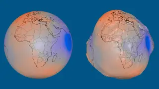
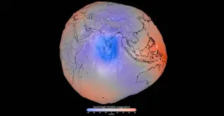
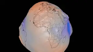
NASA released a visualization of the geoid—the imaginary sea level defined by gravity and Earth's rotation—showing Earth as a potato‑like shape caused by uneven mass distribution. The geoid is not the planet's physical surface; the display exaggerates height variations 10,000× to illustrate how gravity varies across the globe. Real differences reach about 85 meters above the reference near Iceland and 106 meters below it south of India, with a total range around 191 meters. The visualization combines more than a billion observations from 19 satellites over 15 years (e.g., GRACE and GOCE) and helps researchers study gravity changes for mapping, surveying, and navigation.

Earth and Venus: near-twins with divergent fates and a metallic frost mystery
science1 month ago

Earth and Venus: near-twins with divergent fates and a metallic frost mystery

Earth and Venus are nearly the same size and gravity, but Venus may host a radar-bright highland coating of lead- and bismuth-sulfide compounds—metallic frost that is not yet confirmed. The mystery ties into how two similar worlds evolved such different climates and histories, and NASA’s DAVINCI and VERITAS missions will probe Venus’s atmosphere and surface to constrain its past water, atmospheric chemistry, and surface composition, while leaving the timing and exact path of their divergence unresolved.

Radical Sunshield Plan Aims to Keep Earth Habitable as the Sun Fades
science2 months ago

Radical Sunshield Plan Aims to Keep Earth Habitable as the Sun Fades

A controversial thought experiment outlines a hyper-ambitious plan to keep Earth's habitability as the Sun expands: deploy a gigantic sunshade at the L1 point to block sunlight, power it with lasers from fusion reactors in Jupiter's atmosphere, use asteroid slingshots to move Earth outward, and even propose antimatter injections and future solar-system maneuvers to dodge Andromeda—claims it could extend life for 9.1 million billion years, but it is presented as speculative and not a practical blueprint.

Titan's distance to Earth is a moving target, shifting radio delays from an hour to 90 minutes
science2 months ago

Titan's distance to Earth is a moving target, shifting radio delays from an hour to 90 minutes

Earth and Saturn orbit the Sun at different speeds, so Titan’s distance from Earth varies between about 1.2 and 1.65 billion kilometres. This causes one-way radio signals to take roughly an hour to 90 minutes, with exact timing depending on planetary alignment and Saturn's elliptical orbit; missions like Cassini–Huygens and the Dragonfly rotorcraft illustrate how communication timing is a moving target, not a fixed distance.

Mercury Overtakes Venus as Earth's Average Nearest Neighbor
science2 months ago

Mercury Overtakes Venus as Earth's Average Nearest Neighbor

A 10,000-year orbital simulation finds Mercury is Earth’s nearest planet on average (about 1.04 AU) while Venus can make closer approaches, revealing that ‘nearest’ has three meanings: closest approach, instant proximity, and the smallest long-term average distance; the result explains why textbooks often cite Venus for closest approach even though Mercury is closer on average.

Earth as a Tiny Speck: Mars rover captures a rare Earth-Phobos moment
space2 months ago

Earth as a Tiny Speck: Mars rover captures a rare Earth-Phobos moment

NASA’s Perseverance rover used the Mastcam-Z camera to produce a grainy composite showing Earth as a tiny bright dot passing behind Mars’ moon Phobos on July 2, 2026. It’s the first time Earth has been photographed from the surface of another planet while an astronomical object occluded it, achieved by stacking nine frames and processing to darken the background; the event also nods to earlier Earth-from-Mars shots by Spirit (2004) and Curiosity (2014).

NASA’s gravity map paints Earth as a potato-shaped geoid, not a real sphere
science2 months ago

NASA’s gravity map paints Earth as a potato-shaped geoid, not a real sphere

NASA's high-precision geoid map reveals subtle gravity highs and lows across Earth; the potato-like visualization is a magnified representation and does not show the planet's actual shape. The geoid model improves GPS accuracy, sea-level monitoring, and understanding Earth's interior, built from GOCE and GRACE data over 15 years, with notable gravity highs near Iceland and lows south of India.

NASA’s gravity-based geoid visual reveals Earth's irregular surface
science2 months ago

NASA’s gravity-based geoid visual reveals Earth's irregular surface

NASA released a gravity-based geoid visualization showing how the ocean surface would look under gravity alone (tidal and wind effects removed). Exaggerating gravity differences 10,000× highlights irregularities caused by dense interior regions, with the geoid peaking near Iceland (about 279 feet above the global average) and dipping south of India (about 348 feet below). Derived from over a billion measurements from the GOCE and GRACE satellites across ~15 years, the highly detailed geoid is not Earth’s physical shape but a tool to improve navigation, topographic surveys, and our understanding of the planet’s interior.