Clear Skies Ahead for Perseid Meteor Shower Viewing
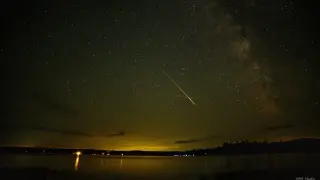
Forecasters expect much clearer skies Thursday night and likely Friday night, improving viewing conditions for the Perseid meteor shower according to local meteorologist Peter Hall.
All articles tagged with #weather forecast

Forecasters expect much clearer skies Thursday night and likely Friday night, improving viewing conditions for the Perseid meteor shower according to local meteorologist Peter Hall.

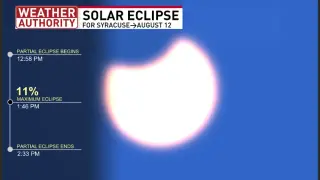
A small partial solar eclipse is forecast for Wednesday afternoon. Local meteorologists outline when to view it, emphasize eye safety for sun-watching, and note factors like cloud cover that could affect visibility, with a short-term stay-seasonable forecast.

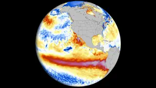
Forecasters project the current El Niño to become the strongest on record, intensifying the global heat signal and making regional weather shifts more predictable. Impacts will vary by location and season, with potential droughts or floods in different regions, a milder US winter in the north and wetter fall/winter in the south, and likely record warmth in 2026–27.

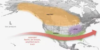
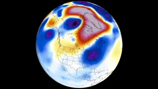
A Super El Niño is rapidly strengthening toward a near-record peak for 2026–27, with August–early fall signals showing a locked atmospheric standing wave that will reshape fall and winter patterns. In North America, expect warmer conditions across the central U.S. and Canada, wetter conditions in the eastern U.S. and parts of Canada, and a stronger Pacific jet that boosts rainfall and storm potential in the south; winter could feature a split-flow pattern with storms concentrated from the Central/Southern Plains to the Mid-Atlantic and cooler air intruding into the South, reducing northern snowfall. Europe may see warmer central/western regions with more autumn rainfall. Forecasters will provide weekly updates as the event evolves.

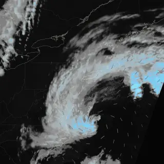
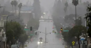
Forecasters warn slow-moving storms could dump 5–7 inches of rain on New York City Tuesday night into Wednesday, with some areas seeing 2–3 inches per hour and a National Weather Service flood watch in effect through Wednesday. The threat includes potentially life-threatening flooding and damaging winds (60–70 mph); NYC Emergency Management has issued a travel advisory and advised residents in basements to move to higher ground. Stay updated via Notify NYC, as unsettled weather could linger into Friday.

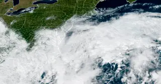
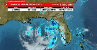
Tropical Depression Two has formed over the northeastern Gulf with a more defined center and 30 mph winds, moving northwest and bringing scattered thunderstorms and gusty winds; meteorologists expect Tropical Storm Bertha to form soon, bringing heavy rainfall to the northern Gulf Coast, with tropical-storm watches in effect from Ochlockonee River to the Florida/Alabama border; the system is not expected to intensify beyond a tropical storm.

Another day of dangerous heat grips the DC region as an Extreme Heat Warning remains in effect from 10 a.m. to 8 p.m., with temperatures hitting 100–105°F and heat index around 110–112°F; Reagan National and Dulles airports could set daily records. Health officials warn the heat is especially harmful at night and urge hydration, light clothing and seeking air-conditioned spaces, while noting poor air quality. The heat could stress power, transit and water systems, and a Capitol Fourth concert will open later due to the conditions. Isolated storms are possible later today, with a more widespread risk of severe storms and potential flash floods over the weekend that could affect Fourth of July plans.

A dangerous heat wave is forecast to build across central and eastern parts of the United States this week, with temperatures expected in the 90s to low 100s and the potential for triple-digit heat in some areas by the Fourth of July weekend, possibly breaking regional records. Forecasters from the Weather Prediction Center, including meteorologist Marc Chenard, warn of extreme heat and heat‑index risks, with detailed forecast maps available. Readers should plan for heat safety, stay hydrated, and limit outdoor activity during peak sun.

A rare tornado watch covers parts of New England today as thunderstorms could turn severe this afternoon. The threat depends on a warm front lifting north and sufficient instability; strongest activity is expected in Vermont and western Massachusetts/Connecticut, with damaging winds (up to ~45 mph) and a possible brief tornado if storms organize. The window for impact is roughly noon to 9 p.m., so stay weather-aware.

The National Hurricane Center is monitoring Potential Tropical Cyclone One, forecast to strengthen into Tropical Storm Arthur by Wednesday morning as it moves through the western Gulf toward Louisiana and Texas.

Baltimore is baking under hot, humid conditions today with temperatures pushing into the 90s; forecasters warn of a risk of severe thunderstorms tonight, followed by cooler, less humid air moving in later this week as a pattern shift brings relief.

Following qualifying for the Miami GP, the FIA will hold two meetings to decide if Sunday’s 4:00pm start should be moved due to forecasts of heavy rain and thunderstorms, with Florida lightning rules potentially forcing suspensions; safety remains the priority, and F2 and Porsche Cup schedules could be shuffled if needed while the forecast stays uncertain.

Forecasters warn a fresh round of severe weather is expected across the central U.S. Friday into the weekend, bringing the threat of strong tornadoes, large hail, damaging winds and flash flooding. The Upper Mississippi Valley faces the highest tornado risk, with more than 51 million people from Texas to Wisconsin under threat as communities continue to recover from recent storms. The Chicago area remains under a tornado watch, and a Saturday threat extends to Cincinnati, Cleveland, Pittsburgh and Buffalo. Michigan is dealing with record flooding and a state of emergency has been declared in 33 counties, while a cold front moving east will bring cooler air to the East next week.

A line of powerful storms swept the central United States, triggering tornado watches and warnings from Texas to the Great Lakes, after a tornado struck Ottawa, Kansas. Forecasters warn of several days of severe weather across the region, with watches issued for Iowa, Minnesota and Wisconsin and a flash flood warning in Green Bay as conditions stay volatile.

Sunny, hot weather and drying, crusty greens pushed Augusta National toward a brutal, fast test in the Masters opening round, with only a handful of under-par holes and an average score around 74.7; Rory McIlroy shot 67 to lead at 5-under as players navigated razor-thin margins that could tighten further if conditions firm up over the next three days.